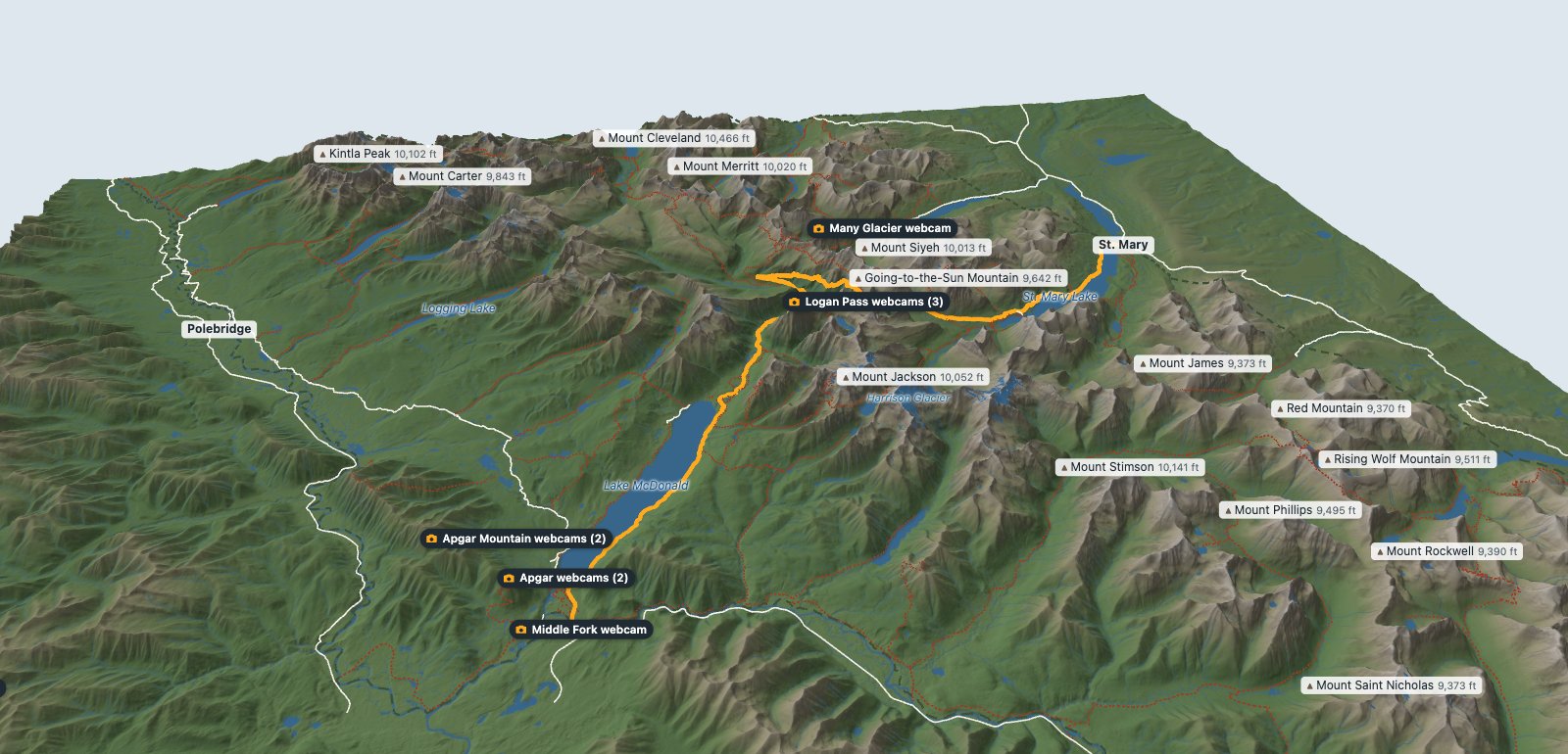
This Glacier National Park map is built in 3D from the ground up: 30-meter elevation data for the whole park, with the Park Service’s own roads, trails, and boundary laid on top. Turn it to see how the Continental Divide splits the park, follow Going-to-the-Sun Road over Logan Pass, and switch on the 1966 glacier outlines to see how much ice is gone. I’ve also placed markers on the map where live webcams are active.
How to Use the Map
- Move around: drag to turn the park, scroll or pinch to zoom. Labels for smaller peaks, lakes, and passes appear as you get closer.
- Read any spot: point at the terrain and the box in the corner shows latitude, longitude, and elevation.
- Fly the road: the Fly the Sun Road button follows Going-to-the-Sun Road from West Glacier to St. Mary. Tap the map to stop.
- Layers: switch the road, other roads, NPS trails, the park boundary, and the 1966 glacier outlines on and off.
- Height: the slider exaggerates the mountains so the valleys read better from far away. Set it to 1 for true proportions.
Reading the Park From Above
The West Side and Lake McDonald
From West Glacier, the long blue shape running northeast is Lake McDonald, the park's biggest lake. Going-to-the-Sun Road follows its eastern shore to Lake McDonald Lodge, about 10.8 miles in, then climbs the McDonald Creek valley toward The Loop. Our guide to where to stay near Glacier National Park uses the same split between the west and east sides.
Logan Pass and the Continental Divide
The gold line crosses the Continental Divide at Logan Pass, 6,646 feet. North of the pass, the trail line along the cliffs is the Highline Trail. To the south, zoom in on Hidden Lake below Bearhat Mountain. Our Going-to-the-Sun Road guide covers every stop and the 2026 parking rules.
The East Side Valleys
East of the divide, the valleys open onto the prairie. St. Mary Lake sits at the east end of the road. Many Glacier is the valley to the north with Swiftcurrent Lake and Lake Sherburne, and Two Medicine is the cluster of lakes to the south. The 3-day Glacier itinerary spends its last day in Many Glacier.
The North Fork
The quiet northwest corner, along the North Fork of the Flathead River, holds Bowman and Kintla Lakes and the small town of Polebridge. On the map it looks as remote as it is: long lakes, few roads, and the Livingston Range rising behind them.
Going-to-the-Sun Road, Mile by Mile
The road runs about 50 miles from US-2 at West Glacier to St. Mary. For the first 16 miles it barely climbs, running along Lake McDonald and McDonald Creek. Past The Loop it gains about 2,300 feet in 7.8 miles to reach Logan Pass, then drops more gently down the east side to St. Mary Lake.
| Stop | Miles from West Glacier | Elevation |
|---|---|---|
| Apgar | 2.0 | about 3,200 ft |
| Lake McDonald Lodge | 10.8 | about 3,260 ft |
| Avalanche | 16.3 | about 3,450 ft |
| The Loop | 24.1 | about 4,290 ft |
| Logan Pass | 31.9 | 6,646 ft (NPS) |
| Siyeh Bend | 34.7 | about 5,860 ft |
| Jackson Glacier Overlook | 36.5 | about 5,330 ft |
| Sun Point | 40.1 | about 4,680 ft |
| Rising Sun | 43.8 | about 4,520 ft |
| St. Mary | 49.4 | about 4,500 ft |
How Much Ice Is Left
Switch on the "Glacier ice in 1966" layer and dashed blue outlines appear around the white ice of 2015. Both come from U.S. Geological Survey mapping. The USGS measured 39 glaciers, the park's 37 named glaciers plus two on Forest Service land, and found they shrank by an average of 39 percent between 1966 and 2015, some by as much as 85 percent (USGS).
The USGS counts an ice body as a glacier once it covers more than 25 acres. By 2015, 26 of the 39 were still that big. Around 1850, at the end of the Little Ice Age, the park had about 80 (USGS glacier status). Zoom in on Sperry Glacier above Lake McDonald or Grinnell Glacier above Many Glacier to see the gap between the two outlines.
The Tallest Peaks
| Peak | Elevation |
|---|---|
| Mount Cleveland | 10,466 ft |
| Mount Stimson | 10,141 ft |
| Kintla Peak | 10,102 ft |
| Mount Jackson | 10,052 ft |
| Mount Merritt | 10,020 ft |
| Mount Siyeh | 10,013 ft |
All six show on the map with their heights. Mount Cleveland rises above Waterton Lake near the Canadian border, Mount Siyeh stands over the road east of Logan Pass, and Mount Jackson and Mount Stimson anchor the high country south of the road.
Where the Map Comes From
- Terrain: Copernicus GLO-30 elevation data, downloaded through OpenTopography.
- Roads, trails, boundary, lodges, and visitor centers: the National Park Service's public map layers for Glacier.
- Lakes: the USGS National Hydrography Dataset. Streams, waterfalls, passes, and peak heights: OpenStreetMap contributors. Place names: USGS.
- Glacier outlines: USGS surveys from 1966 and 2015, through the GLIMS glacier database.
- Limits: the elevation readout comes from the terrain data and runs a little low on sharp summits, so the peak labels use surveyed heights instead. Trails change; check the Park Service for closures.
Glacier National Park Map FAQ
Is there a 3D map of Glacier National Park?
Yes. The map on this page is a 3D model of the whole park built from 30-meter elevation data, with the Park Service's roads, trails, and boundary, named peaks with their heights, lakes, and glacier outlines. Drag to turn it, scroll or pinch to zoom, and point at any spot to read its elevation.
What is the highest peak in Glacier National Park?
Mount Cleveland, near the Canadian border, at 10,466 feet. Some sources list 10,479 feet because they use a newer vertical datum. Six peaks in the park top 10,000 feet.
How many glaciers are left in Glacier National Park?
The U.S. Geological Survey measured the park's 37 named glaciers plus two on nearby Forest Service land. In 2015, 26 of them were still larger than 25 acres, the size the USGS uses to count an ice body as a glacier. Around 1850 there were about 80.
How high does Going-to-the-Sun Road climb?
From about 3,200 feet near West Glacier to 6,646 feet at Logan Pass, roughly 32 miles up the road. Most of that climb comes in the eight miles between The Loop and the pass.
Can I use this map to navigate on a hike?
No. Use it to plan and to understand the terrain. On the trail, carry the official park map or a dedicated GPS app, and check the Park Service for trail closures before you go.
Ready to go? Start with the best things to do in Glacier National Park and the 2026 entry rules.